RoboGEO versions

RoboGEO enables us to input geocoding data into maps
6.3
Mar 11, 2012
Review
6.1
Sep 5, 2011
Review
5.9
Mar 9, 2011
5.8
Jan 31, 2011
5.7
Oct 21, 2010
5.6
Oct 20, 2008
Editorial review
rating
5.4
Jul 1, 2008
Review
5.3
Jan 1, 2008
Review
5.2
Review
5.1
Jun 5, 2008
Review
5.0
Review
4.4
Review
4.3
Review
4.2
Review
4.1
Review
4.0
Review
3.4
Review
3.3
Review
3.2
Review
3.1
Review
3.0
Review
2.1
Review
2.0
Review
1.0
Review

What's new

v6.3 [Sep 19, 2011]
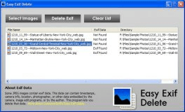
-Write to the EXIF Headers
-Stamp the Images
-Geocode Photos Using Google Earth

v6.1 [Sep 5, 2011]
Added the ability to import CSV files that are exported from the 'CAP Image Processor' application's 'Template Work Sheet'.

v5.3 [Jan 1, 2008]
Upload waypoints, Google Maps terrain view, Google Earth timelines, and Garmin MapSource GPX extension

Alternative downloads

Garmin Express
Garmin Express
Free
rating

Set up, register, and update your Garmin device and maps.

Easy Exif Delete
Easy Exif Delete
Free
rating

Free useful tool to remove all EXIF data present in your JPEG photographs.

MSR MapCruncher for Virtual Earth
MSR MapCruncher for Virtual
Free
rating

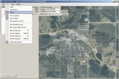
A tool for integrating the maps of your choice into the Virtual Earth API.

3DVista Real Estate
3DVista Real Estate
rating

It is the All-in-One property presentation (virtual tours) & management tool.

Geo-Tag Mapper
Geo-Tag Mapper
Free
rating

Plot geotagged images in a selected folder on a virtual globe